
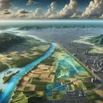
Digital Terrain Models (DTM)
April 26, 2024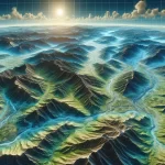
Digital Elevation Models (DEM)
April 26, 2024
Digital Surface Model (DSM) is a powerful tool in geospatial analysis that provides a comprehensive view of the Earth’s surface. In this ultimate guide, we will explore the basics of DSM, its components, the process of creating a DSM, different types of DSMs, and its various applications in fields such as urban planning, environmental studies, and disaster management.
Understanding the Basics of DSM
Before diving into the details, let’s start by defining what a Digital Surface Model is and understanding its importance in geospatial analysis.
Imagine standing on a hilltop, gazing out at the breathtaking landscape before you. You see the rolling hills, the towering trees, and the shimmering lakes. Now, imagine being able to capture that entire scene in a single digital representation. That’s exactly what a Digital Surface Model (DSM) does.
Defining Digital Surface Model
A Digital Surface Model (DSM) is a representation of the Earth’s surface that includes both natural and man-made features. It provides a 3D visualization of the terrain, including buildings, vegetation, water bodies, and other above-ground objects. DSMs are commonly used in various fields, such as cartography, urban planning, and environmental studies.
DSMs are like a virtual mirror that reflects the Earth’s surface in stunning detail. They capture not only the physical features but also the intricate nuances of the landscape. With a DSM, you can explore every nook and cranny, every rise and fall of the land, without leaving the comfort of your desk.
Importance of DSM in Geospatial Analysis
DSMs play a crucial role in geospatial analysis by providing accurate and detailed information about the Earth’s surface. They are used to assess land cover, detect changes in elevation, analyze slope and aspect, and conduct other spatial analyses. DSMs are the foundation for a wide range of applications, making them an essential tool for professionals in the geospatial industry.
Imagine you are an urban planner tasked with designing a new city park. By utilizing a DSM, you can analyze the terrain to determine the best location for the park, taking into account factors such as slope, vegetation coverage, and proximity to water bodies. With this valuable information, you can create a park that not only harmonizes with the natural landscape but also provides a safe and enjoyable environment for the community.
Components of a Digital Surface Model
A DSM is created using various data sources and processing techniques. It consists of several components, including:
- Elevation Data: The primary input for creating a DSM is elevation data, which can be collected using remote sensing techniques (e.g., LiDAR) or derived from topographic maps. This data provides the foundation for accurately representing the Earth’s surface.
- Vegetation and Buildings: DSMs capture the height and shape of vegetation, buildings, and other structures on the Earth’s surface. This information is crucial for understanding the impact of man-made features on the landscape and for conducting urban planning studies.
- Water Bodies: DSMs accurately represent the shape and extent of lakes, rivers, and other water bodies. This information is invaluable for hydrological studies, flood risk assessment, and environmental monitoring.
- Terrain Features: DSMs include natural terrain features such as hills, valleys, and mountains. These features provide valuable insights into the topography of an area, allowing for better understanding and analysis of the landscape.
Each component of a DSM contributes to the overall richness and accuracy of the model. By combining these elements, geospatial professionals can create a comprehensive representation of the Earth’s surface, enabling a deeper understanding of our environment.
The Process of Creating a DSM
Creating a Digital Surface Model (DSM) is a meticulous process that requires attention to detail and precision. Each step in the creation of a DSM plays a crucial role in producing an accurate representation of the Earth’s surface. Let’s delve deeper into the intricacies of this fascinating process.
Data Collection for DSM
The foundation of a DSM lies in the data collection phase, where various techniques are employed to gather elevation data. Aerial surveys, satellite imagery, and ground-based measurements are some of the methods used to acquire the necessary information. Among these techniques, LiDAR stands out for its ability to provide highly precise elevation data. By emitting laser pulses and measuring the time it takes for the light to return, LiDAR technology enables the creation of detailed elevation models with remarkable accuracy.
Processing and Interpreting DSM Data
Once the raw elevation data is obtained, the next step involves processing and interpreting this information to generate a comprehensive DSM. This intricate process includes filtering out any noise or anomalies, eliminating outliers, and interpolating elevation values to ensure a seamless representation of the terrain. Advanced algorithms are employed during this stage to refine the data and enhance the overall quality of the DSM.
Quality Control in DSM Creation
Ensuring the reliability and accuracy of a DSM is paramount, which is why quality control measures are rigorously implemented throughout the creation process. By comparing the DSM with ground control points, validating elevation values, and conducting thorough error analyses, the integrity of the model is upheld. These meticulous quality control procedures guarantee that the DSM is not only precise but also dependable for a wide range of applications.
Different Types of Digital Surface Models
There are different types of DSMs, each serving specific purposes. Let’s explore some of the most commonly used types.
Digital Surface Models (DSMs) play a crucial role in various industries, providing valuable insights into the Earth’s surface characteristics. By utilizing remote sensing technologies and advanced algorithms, DSMs offer detailed representations of terrain features, aiding in decision-making processes and resource management strategies.
Bare Earth DSM
A Bare Earth DSM represents the terrain’s surface without any vegetation or man-made structures. It is generated by removing vegetation and buildings from the elevation data, providing a clear view of the underlying topography. Bare Earth DSMs are commonly used in hydrological modeling, land surveying, and land management applications.
These models are essential for analyzing slope stability, identifying potential erosion hotspots, and determining suitable locations for infrastructure development. By isolating the bare earth components, professionals can accurately assess the natural landscape’s characteristics and plan interventions to mitigate environmental risks.
First Surface DSM
A First Surface DSM includes all the features present on the Earth’s surface, including vegetation, buildings, and other structures. It provides a complete representation of the visible surface, making it valuable for applications such as urban planning, forestry, and environmental impact assessment.
Urban planners utilize First Surface DSMs to simulate urban growth patterns, assess green space distribution, and analyze the impact of new developments on the existing landscape. These models enable stakeholders to visualize the potential changes in land use and make informed decisions regarding sustainable urban development practices.
DSM vs. Digital Terrain Models
While DSMs and Digital Terrain Models (DTMs) share similarities, they serve different purposes. A DSM represents the Earth’s surface, including both natural and man-made features, whereas a DTM only represents the bare terrain without any above-ground objects. DTMs are primarily used in engineering applications such as road construction, slope stability analysis, and flood modeling.
Engineers rely on DTMs to design transportation networks, assess the feasibility of construction projects, and evaluate the impact of natural disasters on infrastructure. By focusing solely on the bare terrain, DTMs provide essential information for calculating earthwork volumes, determining cut and fill requirements, and optimizing construction processes to ensure project efficiency and safety.
Applications of Digital Surface Models
The versatility of Digital Surface Models (DSMs) has led to their wide range of applications in various industries. Let’s explore some of the key applications.
Use of DSM in Urban Planning
DSMs play a crucial role in urban planning by providing valuable insights into elevation differences, building heights, and land cover. Urban planners use DSMs to assess the impact of new developments, analyze sight lines, and plan transportation networks. For example, by analyzing the DSM, urban planners can determine the best locations for new roads or public transportation systems, taking into account the existing topography and potential obstacles. DSMs also aid in flood risk assessment and the design of drainage systems in urban areas. By accurately representing the terrain, DSMs help identify areas prone to flooding and enable the implementation of effective flood prevention measures.
Furthermore, DSMs are also used in the analysis of urban heat islands, which are areas with significantly higher temperatures compared to their surrounding areas. By analyzing the DSM and combining it with other data such as land cover and temperature measurements, urban planners can identify areas that are more susceptible to heat islands and develop strategies to mitigate their effects. This can include the implementation of green infrastructure, such as parks and green roofs, to reduce the overall temperature and improve the quality of life for urban residents.
DSM in Environmental Studies
In environmental studies, DSMs are used to monitor changes in land cover, analyze the impact of deforestation and urbanization, and assess the health of ecosystems. By combining DSMs with other geospatial data, researchers can gain a better understanding of the Earth’s surface dynamics and make informed decisions for sustainable development. For instance, DSMs can be used to track the expansion of urban areas and quantify the loss of natural habitats. This information is crucial for developing conservation strategies and protecting biodiversity.
Moreover, DSMs are valuable tools in studying the effects of climate change on the environment. By analyzing changes in elevation and land cover over time, researchers can assess the vulnerability of different regions to rising sea levels, coastal erosion, and other climate-related phenomena. This information is essential for developing adaptation plans and mitigating the impacts of climate change on both natural and human systems.
Role of DSM in Disaster Management
DSMs are invaluable in disaster management for assessing vulnerability and planning emergency response. They help identify areas prone to flooding, landslides, or erosion by analyzing slope, aspect, and elevation differences. By accurately representing the terrain, DSMs enable authorities to identify high-risk areas and implement measures to reduce the impact of natural disasters.
Furthermore, DSMs also assist in the estimation of flood volume and the planning of evacuation routes, enabling authorities to mitigate risks and save lives. By analyzing the DSM and simulating different flood scenarios, emergency management teams can develop effective evacuation plans and allocate resources more efficiently. Additionally, DSMs can be used to assess the stability of slopes and identify areas at risk of landslides, allowing for early warning systems and preventive measures to be implemented.
In conclusion, Digital Surface Models (DSMs) provide a detailed representation of the Earth’s surface, encompassing both natural and man-made features. They are vital tools in geospatial analysis, enabling professionals to analyze terrain, detect elevation changes, and conduct various spatial analyses. By understanding the basics of DSMs, the process of creating them, the different types available, and their wide-ranging applications, we can leverage this powerful technology to make informed decisions and drive sustainable development.